
Walk a West Bend Street
A West Bend street directory search works best as a chain, not as a request for one master list. Current assessment and tax records identify the owner that government records connect to a parcel. They do not name each person who sleeps there. WashCoGIS supplies the map link, road segment, municipality, parcel outline, and tax key. A recorded deed supplies a dated transaction. A permit may identify an owner or contractor at the time of a project. Phone books and county directories add older, incomplete subscriber or address evidence.
- Enter the complete property address in AssessorData, or use a known tax key. Save the displayed form of the address.
- Open WashCoGIS, locate the road segment, click the parcel, and copy its tax key and municipality.
- Compare the key in county LandRecords or Tax Inquiry. Note the owner, physical address, mailing address, legal description, and parcel history.
- Use the owner and legal description in LandShark. Read the purchase deed, then follow grantors and prior grantees backward.
- Add permits, properly requested voter data, phone books, county directories, maps, and archive material. Put a date beside every name.
This sequence keeps unlike facts apart. An owner mailing address can be outside West Bend while the physical, or situs, address remains in the city. A deed shows a transfer on its recording date. A listed phone subscriber is not proof of every household member. When several unit addresses share one parcel, inspect the condominium or subdivision plat before assigning one owner to every door.
West Bend Address Search Fields
The City of West Bend links its assessment data to AssessorData. The public landing screen exposes two dependable routes after choosing Washington County: a property street address or a tax key. An owner-name field was not visible during research, so the address is the sound starting point. For questions about how a value was set, contact the city assessor. The assessor lists and values property within the city but does not collect taxes or set tax rates.
| Visible field | Input | Use in a street search |
|---|---|---|
| County | Select Washington County | Limits the property system to the correct county |
| Property street address | Full address | Finds the assessed property by address |
| Tax key | Known parcel identifier | Reconnects a GIS or tax result to the assessment record |
| Owner name | Not exposed on landing screen | Do not promise this mode without checking the live portal |
The assessor's office is at City Hall, 1115 S Main Street, and can be reached at 262-335-5125 or wbassessor@westbendwi.gov. Its posted hours are Monday through Friday, 8:00 a.m. to 4:30 p.m. That direct channel matters when the portal cannot resolve a unit, an address was entered in another format, or the displayed municipality is uncertain.
The assessment search screen shows the county, street-address, and tax-key choices used for the first step.
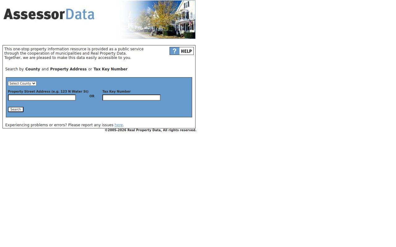
Its limited landing fields are why a whole-street project moves next to the county map instead of assuming an address-only portal can export every property.
Map West Bend Parcels by Street
Washington County reports that all county parcels are digitally mapped. Its land-information plan describes tax-key links within parcel polygons and nightly extraction of common tax-roll attributes. In WashCoGIS, pan to a road, select a parcel or address point, then move along the centerline and click adjacent polygons. If the popup lacks an owner link, copy the tax key into LandRecords or Tax Inquiry.
The map service includes roads, centerlines, parcels, rights-of-way, intersections, municipalities, railroads, wards, polling places, districts, water, open space, and trails. Identify, Query, Find, and Export Map operations are advertised, with a 2,000-record selection limit. A parcel shape is a discovery aid, not a legal survey. Narrow broad work to a short segment and verify the result against the current parcel detail.
- Parcel
- A mapped unit of land connected to a tax key. One parcel may hold more than one address.
- Situs address
- The physical location of the property, which can differ from the owner's mailing address.
- Plat
- A recorded map that identifies lots, blocks, subdivisions, condominiums, or other divisions of land.
- Criss-cross directory
- A directory arranged by street or address instead of only by surname. West Bend lacks a verified typical series.
West Bend Street Record Sources
Each address-keyed source answers a separate part of a West Bend street directory question. Use the table as an evidence map. Online access is only one channel. City and county staff can handle a narrow request by address, parcel, record type, and date range, while the library and Tower Heritage Center provide older material that is not exposed as a modern portal.
| Record Set | Keeper | What It Shows | Access |
|---|---|---|---|
| Assessment and tax | City Assessor; county Treasurer/LandRecords | Owner, physical and mailing address, legal description, values, tax and parcel history | Web, office, phone, or focused request |
| GIS parcel map | Washington County GIS | Parcels, address points, roads, municipality, ZIP, ward, and district layers | Public web app and REST map |
| Deeds, liens, and plats | Washington County Register of Deeds | Recorded parties, dates, documents, legal descriptions, and ownership chain | Free LandShark name search; paid images; counter/contact |
| Voter data | Wisconsin Elections Commission or clerks | Unprotected registration data through authorized procedure | Written request and fees; MyVote is self-service only |
| Building permits | City Building Inspection | Project address, parcel, owner, work, cost, contractor, and inspection evidence | Phone, email, or public-record request; no public results search verified |
| Historical directories | Library and Tower Heritage Center | Listed subscriber, phone, business, or county-directory address by year | Catalog, reference desk, phone, email, reading room |
The tax key is the strongest join between the current map, tax detail, and many land records. Street names can vary, and a recorded instrument may be indexed by person or legal description rather than a postal address. Keep both the address and the parcel identifier. A narrow Wisconsin Public Records Law request under Wis. Stat. §§19.31–19.39 can ask a custodian for existing permit or GIS records when a portal does not expose them.
Follow West Bend Deeds by Address
LandShark is the county's recorded-document route, but an address may not be its best key. Convert the street location into a tax key, lot and block, subdivision, tract, or full legal description. Search the current owner's purchase document. Record the grantor, grantee, document number, recording date, book and page or image reference, and legal description. Then search that grantor as an earlier grantee and repeat.
Name searching is free. Viewing or printing a document costs $2 for its first page, $1 for each added page, plus a $3 convenience fee. The county calls LandShark a working index, so spelling and indexing errors remain possible even though index entries are double-verified after recording. Pale ink and older, hard-to-read pages can also limit an image. Compare the legal description at every step, especially after a split, merger, condominium filing, or transfer of only part of a tract.
Recorded is not resolved. A LandShark entry documents a filing; it does not prove that the recorder tested title validity or prevented fraud.
West Bend Permits Date Changes
City Building Inspection files can date work at a street address. The city's permit application captures the project address, parcel number, owner contact, work type and description, cost, contractor identity and license information. That makes a permit useful when a deed says who owned a parcel but not when a building changed. No public permit-results database or archive start year was verified.
Ask Building Inspection at 262-335-5140 or inspect@westbendwi.gov for existing records tied to an exact address or parcel and a useful date span. Request permits, inspection results, orders, notices, and closed cases as distinct record types because they may sit in separate systems. The office is at City Hall and posts weekday hours from 8:00 a.m. to 4:30 p.m. A custodian need not create a new resident-history report, so describe the records sought rather than the conclusion desired.
Voter Data Is Not Street Browse
MyVote requires a first name, last name, and date of birth. It lets a voter find that voter's own registration, election participation history, officials, and ballot tools. It does not accept a West Bend street as a public browse key. Never turn the self-service match screen into a claimed street roster.
Wisconsin Admin. Code EL 3.50 permits access to unprotected registration data through a written request and applicable charges. The electronic report charge begins with a $25 base, adds $5 for up to the first 1,000 records and $5 for each additional 1,000, with a stated maximum of $12,500. Paper copies are 25 cents per page plus shipping. Protected information must be withheld. West Bend questions can go to the City Clerk, while countywide administration routes through the Washington County Clerk at 262-335-4301.
West Bend Lacks Reverse Directories
A local historic-district nomination states that West Bend has no conventional city directory series with the typical reverse section. That is the key street-directory quirk. Documented phone books span 1930 through 1995, and county directories run from Johnson Publishing for 1969 through 1992 and R.L. Polk for 1995 through 2010. These sources may yield a name, business, phone, or address, but their exact page fields and gaps must be checked in the volume.
Start with the West Bend Community Memorial Library catalog or reference desk. Ask for the target year and whether the volume has an address section, street index, abbreviations, or owner marks. The library is at 630 Poplar Street, telephone 262-335-5151, with reference help at reference@westbendlibrary.org. Tower Heritage Center adds community directories, tax records, newspapers, Sanborn maps, family files, and property research. A detailed treatment of the runs belongs on the West Bend city directory page.
West Bend Streets Across Time
Modern road labels cannot simply be imposed on every old record. The 1859 Washington County map includes landowners, roads, township and range, water, rail features, and a “Westbend” inset. The November 1884 Sanborn map has two sheets showing buildings, businesses, street widths, hydrants, water mains, materials, and fire-risk details in its mapped area. Rail growth in 1872 and 1873 also shifted development east of the Milwaukee River.
No authoritative West Bend street-renaming or renumbering chronology was found. Treat an unmatched old address as unresolved, not wrong. Compare lot and block, legal description, parcel lineage, river or rail position, a building record, and map placement. Search archival catalogs under both “West Bend” and “Westbend.” The 1859 map record is useful for the older landowner landscape rather than present house numbers.

The old map demonstrates why township, road, and parcel context may survive even where a present-day house number does not.
West Bend Record Access Fallbacks
A September 2026 notice says historical paper land books at the Register of Deeds are temporarily unavailable due to construction. The office remains the custodian, but a walk-in book search may fail. Call 262-335-4320 before traveling. The Government Center office at 432 E Washington Street posts Monday through Thursday hours from 7:00 a.m. to 5:30 p.m. and closes Friday.
Use LandShark for indexed names and available images, the county's scanned historic plats and maps, WashCoGIS and LandRecords for parcel context, the Wisconsin Historical Society for maps and microfilm, the library for phone and county books, or Tower Heritage Center for reading-room and staff research. Mail, phone, and focused records requests remain valid channels. None should be represented as a complete substitute for a missing original book.
Limits of West Bend Street Records
A property owner is not always an occupant. Tax and assessment records omit many renters, relatives, children, and other people in a home. Voter data omits nonregistered residents and shields protected information. Phone books omit people who had no listed subscription. Utility customer and delivery lists were not found as open West Bend sources, and driver address information is restricted by federal privacy law and Wisconsin Chapter 343.
Safe at Home participants can register as confidential electors, and their actual addresses must not be disclosed. Parcel geometry is not a survey. A deed index can contain errors, and an old address can predate a modern street number. A responsible street directory worksheet therefore labels each fact as ownership, recorded transaction, registration evidence, subscriber listing, permit event, or map context. It never upgrades one of those facts into an unsupported claim about a full household.
Lawful use. Use West Bend address records only for lawful personal research. Never use them to stalk, harass, threaten, or expose a protected person.